Fayl:Everest-3D-Map-Type-EN.jpg

Sınaq göstərişi ölçüsü: 800 × 600 piksel. Digər ölçülər: 320 × 240 piksel | 640 × 480 piksel | 1.024 × 768 piksel | 1.280 × 960 piksel | 2.560 × 1.920 piksel | 5.000 × 3.750 piksel.
Faylın orijinalı (5.000 × 3.750 piksel, fayl həcmi: 4,28 MB, MIME növü: image/jpeg)
| Bu fayl "Vikimedia Commons"dadır və digər layihələrdə istifadə edilə bilər. |
 |
Faylın təsvir səhifəsinə get |
Xülasə
| İzah |
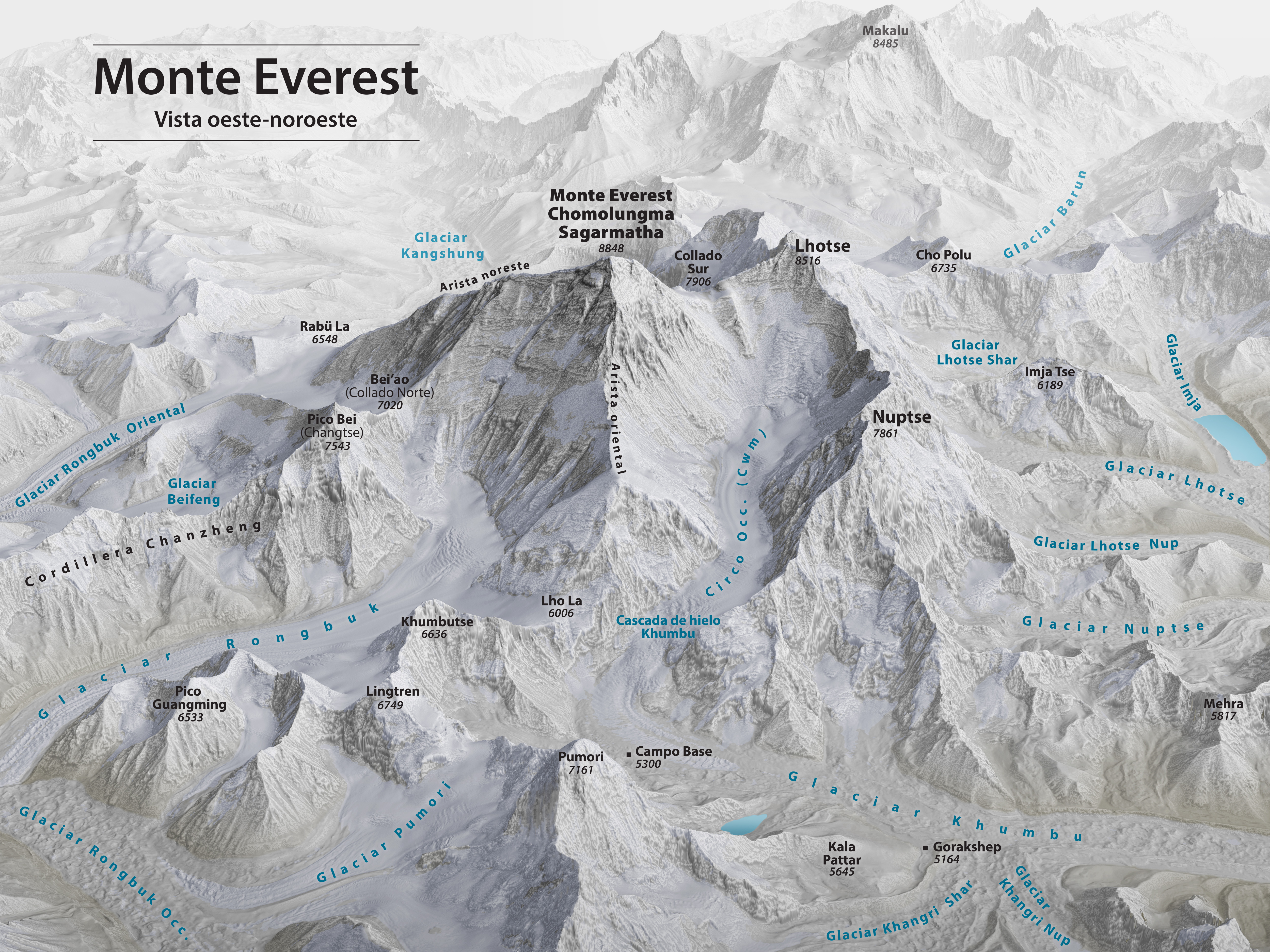
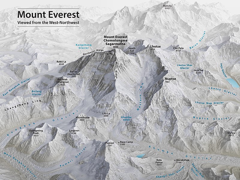
English: Mount Everest 3D Map by Tom Patterson, with English annotation, based on data from the US National Snow and Ice Data Center and Landsat 8. |
||
| Tarix | |||
| Mənbə | http://shadedrelief.com/Everest-3D-Map | ||
| Müəllif | Tom Patterson | ||
| Digər versiyalar |
|

Assessment
|

Lisenziya
| This file is made available under the Creative Commons CC0 1.0 Universal Public Domain Dedication. | |
| The person who associated a work with this deed has dedicated the work to the public domain by waiving all of their rights to the work worldwide under copyright law, including all related and neighboring rights, to the extent allowed by law. You can copy, modify, distribute and perform the work, even for commercial purposes, all without asking permission.
|
License note: Source page at this link archived here states: "Terms of Use - The maps on this page are in the public domain. You may use them any way you like, including modifying the content, digital and print reproduction, and selling them for profit. Consider these maps as yours."
Faylın tarixçəsi
Faylın əvvəlki versiyasını görmək üçün gün/tarix bölməsindəki tarixlərə klikləyin.
| Tarix/Vaxt | Kiçik şəkil | Ölçülər | İstifadəçi | Şərh | |
|---|---|---|---|---|---|
| indiki | 00:53, 19 noyabr 2020 | | 5.000 × 3.750 (4,28 MB) | Cmglee | Uploaded a work by Tom Patterson from http://shadedrelief.com/Everest-3D-Map with UploadWizard |
Fayl keçidləri
Bu faylı istifadə edən səhifə yoxdur.
Faylın qlobal istifadəsi
Bu fayl aşağıdakı vikilərdə istifadə olunur:
- bs.wikipedia.org layihəsində istifadəsi
- ca.wikipedia.org layihəsində istifadəsi
- ckb.wikipedia.org layihəsində istifadəsi
- en.wikipedia.org layihəsində istifadəsi
- Mount Everest
- Timeline of Mount Everest expeditions
- Wikipedia:WikiProject Nepal
- Portal:Nepal
- Wikipedia:WikiProject China/Featured and good content
- User:Cmglee
- Wikipedia:Featured pictures/Diagrams, drawings, and maps/Maps
- Wikipedia:WikiProject Geology/Recognized content
- 1953 British Mount Everest expedition
- Wikipedia:WikiProject Geology/Automated list of recognized content
- Talk:Mount Everest/Archive 6
- Portal:Nepal/Recognized content
- Portal:Sports/Recognized content
- Wikipedia:WikiProject Nepal/Recognized content
- Wikipedia:Featured pictures thumbs/69
- Wikipedia:Featured picture candidates/November-2020
- Wikipedia:Featured picture candidates/Mount Everest 3D map
- Wikipedia:Wikipedia Signpost/2020-12-28/Featured content
- Wikipedia:Wikipedia Signpost/Single/2020-12-28
- User:Evad37/Wikipedia:Wikipedia Signpost/Single/2020-12-28
- User talk:Cmglee/archive2020
- Wikipedia:WikiProject Mountains/Recognized content
- Wikipedia:Picture of the day/May 2023
- Template:POTD/2023-05-29
- Wikipedia:Main Page history/2023 May 29
- Wikipedia:Main Page history/2023 May 29b
- ext.wikipedia.org layihəsində istifadəsi
- fi.wikipedia.org layihəsində istifadəsi
- fr.wikipedia.org layihəsində istifadəsi
- id.wikipedia.org layihəsində istifadəsi
- nl.wikipedia.org layihəsində istifadəsi
- sh.wikipedia.org layihəsində istifadəsi