Fayl:Gravity Anomalies on Mercury.jpg Haqqinda Melumat - Vikipedia

Fayl:Gravity Anomalies on Mercury.jpg Haqqinda Melumat - Vikipedia


Siz Geniş ensklopediyada istədiyinizi tapa bilərsiniz

Fayl:Gravity Anomalies on Mercury.jpg

Faylın orijinalı(2.400 × 2.400 piksel, fayl həcmi: 1,03 MB, MIME növü: image/jpeg)

Bu fayl "Vikimedia Commons"dadır
və digər layihələrdə istifadə edilə bilər.
təsvir səhifəsi
təsvir səhifəsi
Faylın təsvir səhifəsinə get

Xülasə

İzah
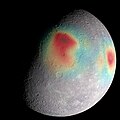
English: Analysis of radio tracking data have enabled maps of the gravity field of Mercury to be derived. In this image, overlain on a mosaic obtained by MESSENGER's Mercury Dual Imaging System and illuminated with a shape model determined from stereo-photoclinometry, Mercury's gravity anomalies are depicted in colors. Red tones indicate mass concentrations, centered on the Caloris basin (center) and the Sobkou region (right limb). Such large-scale gravitational anomalies are signatures of subsurface structure and evolution. The north pole is near the top of the sunlit area in this view. The MESSENGER spacecraft is the first ever to orbit the planet Mercury, and the spacecraft's seven scientific instruments and radio science investigation are unraveling the history and evolution of the Solar System's innermost planet. In the mission's more than four years of orbital operations, MESSENGER has acquired over 250,000 images and extensive other data sets. MESSENGER's highly successful orbital mission is about to come to an end, as the spacecraft runs out of propellant and the force of solar gravity causes it to impact the surface of Mercury in April 2015.
Tarix
Mənbə http://messenger.jhuapl.edu/gallery/sciencePhotos/pics/Mercury_gravity_2015.jpeg
Müəllif NASA/Goddard Space Flight Center Science Visualization Studio/Johns Hopkins University Applied Physics Laboratory/Carnegie Institution of Washington

Lisenziya

Public domain This file is in the public domain in the United States because it was solely created by NASA. NASA copyright policy states that "NASA material is not protected by copyright unless noted". (See Template:PD-USGov, NASA copyright policy page or JPL Image Use Policy.)
Warnings:

Captions

Add a one-line explanation of what this file represents

Items portrayed in this file

təsvir edir

15 aprel 2015

Faylın tarixçəsi

Faylın əvvəlki versiyasını görmək üçün gün/tarix bölməsindəki tarixlərə klikləyin.

Tarix/VaxtKiçik şəkilÖlçülərİstifadəçiŞərh
indiki20:15, 11 fevral 201920:15, 11 fevral 2019 tarixindəki versiyanın kiçildilmiş görüntüsü2.400 × 2.400 (1,03 MB)HuntsterCropped 20 % vertically using CropTool with precise mode.
12:33, 4 dekabr 201512:33, 4 dekabr 2015 tarixindəki versiyanın kiçildilmiş görüntüsü2.400 × 3.000 (1.011 KB)PlanetUser{{Information |Description ={{en|1=Analysis of radio tracking data have enabled maps of the gravity field of Mercury to be derived. In this image, overlain on a mosaic obtained by MESSENGER's Mercury Dual Imaging System and illuminated with a shape...

Aşağıdakı səhifə bu faylı istifadə edir:

Faylın qlobal istifadəsi

Bu fayl aşağıdakı vikilərdə istifadə olunur:

Metaməlumatlar


Saytda 101 nəfər
Top.Mail.Ru
©Tatli.Biz 2010-2024