Fayl:The Wall of ghetto in Warsaw - Building on Nazi-German order August 1940.jpg
Sınaq göstərişi ölçüsü: 760 × 599 piksel. Digər ölçülər: 304 × 240 piksel | 609 × 480 piksel.
Faylın orijinalı (800 × 631 piksel, fayl həcmi: 153 KB, MIME növü: image/jpeg)
| Bu fayl "Vikimedia Commons"dadır və digər layihələrdə istifadə edilə bilər. |
 |
Faylın təsvir səhifəsinə get |
Xülasə
| İzah |
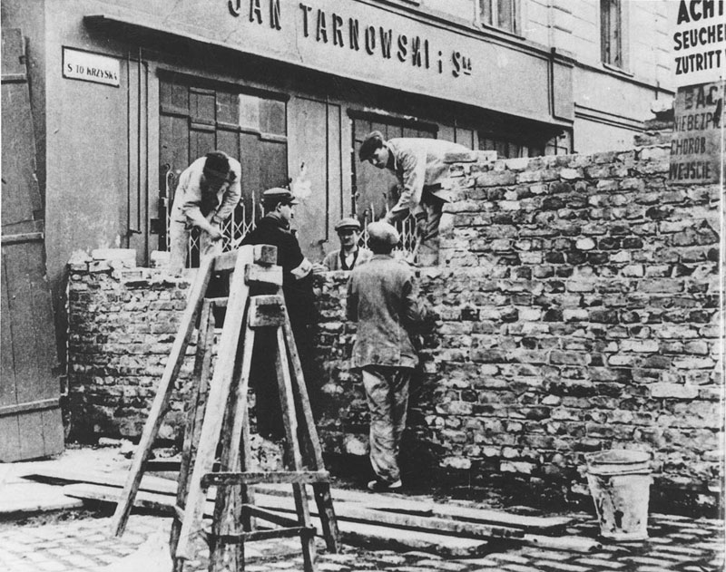
English: Warsaw Ghetto (1940-1943) during the German occupation of Poland: Construction of Ghetto wall across Świętokrzyska street near intersection with Marszałkowska street. In the back "Magazyn Bławatny" store of Jan Tarnowski & Co. at Marszałkowska 133 street. This is not the final location of the wall on Świętokrzyska street, according to book "Getto Warszawskie"[1] in 1941 the wall was a block farther between Zielna and Bagno streets.
Polski: Getto warszawskie: Budowa muru Getta w poprzek ulicy Świętokrzyskiej przy skrzyżowaniu z ulicą Marszałkowską. Z tyłu "Magazyn Bławatny" Jana Tarnowskiego i Ska przy ulicy Marszałkowskiej 133 [1]. Nie jest to ostateczna pozycja muru na ulicy Świętokrzyskiej, wedle map w książce "Getto Warszawskie"[1] w roku 1941 mur getta stał o ulice dalej miedzy ulicami Zieloną i Bagno. Takie tymczasowe mury, budowano od marca-kwietnia 1940 i stawiano je na obrzeżach strefy zamieszkania dla Żydów, noszącej potoczną nazwę Seuchensperrgebiet. Po utworzeniu getta, te mury zostały rozebrane.
|
| Tarix | mart 1940 - oktyabr 1940 |
| Mənbə |
|
| Müəllif | Naməlum |
| İcazə (Faylın təkrar istifadəsi) |
PD-Polish |
![[1]](http://lcweb2.loc.gov/cgi-bin/displayPhoto.pl?path=/service/gdc/scd0001/2002/20020611001wa&topImages=00000398r.jpg&topLinks=00000398v.jpg,00000398u.tif,00000398a.tif,00000398.tif&displayProfile=0)
| Camera location | | View this and other nearby images on: OpenStreetMap |
|---|
Lisenziya
This photograph is in the public domain because according to the Art. 3 of copyright law of March 29, 1926 of the Republic of Poland and Art. 2 of copyright law of July 10, 1952 of the People's Republic of Poland, all photographs by Polish photographers (or published for the first time in Poland or simultaneously in Poland and abroad) published without a clear copyright notice before the law was changed on May 23, 1994 are assumed to be in the public domain in Poland.
This work is in the public domain in the United States because it meets three requirements:
To uploader: Please provide where and when the image was first published.
|
 |
Faylın tarixçəsi
Faylın əvvəlki versiyasını görmək üçün gün/tarix bölməsindəki tarixlərə klikləyin.
| Tarix/Vaxt | Kiçik şəkil | Ölçülər | İstifadəçi | Şərh | |
|---|---|---|---|---|---|
| indiki | 20:26, 15 may 2016 | | 800 × 631 (153 KB) | Tom5551 | better quality |
| 04:11, 12 fevral 2013 |  | 882 × 768 (224 KB) | Jarekt | bigger version from http://d.naszemiasto.pl/k/r/ee/94/50079c410030d_o.jpg | |
| 22:27, 9 fevral 2009 |  | 472 × 411 (90 KB) | Jarekt | larger version | |
| 13:16, 12 iyun 2007 |  | 446 × 347 (67 KB) | Andros64 | {{Information |Description=The_Wall_of_ghetto_in_Warsaw_-_Buiilding_on_Nazi_-German_order_August_1940.j |Source="Warszawskie getto" Warszawa 1988 |Date=1940 |Author=unknown |Permission=PD-Polish |other_versions= }} |
Fayl keçidləri
Aşağıdakı səhifə bu faylı istifadə edir:
Faylın qlobal istifadəsi
Bu fayl aşağıdakı vikilərdə istifadə olunur:
- ar.wikipedia.org layihəsində istifadəsi
- ast.wikipedia.org layihəsində istifadəsi
- azb.wikipedia.org layihəsində istifadəsi
- be.wikipedia.org layihəsində istifadəsi
- ca.wikipedia.org layihəsində istifadəsi
- cs.wikipedia.org layihəsində istifadəsi
- el.wikipedia.org layihəsində istifadəsi
- en.wikipedia.org layihəsində istifadəsi
- eo.wikipedia.org layihəsində istifadəsi
- es.wikipedia.org layihəsində istifadəsi
- fa.wikipedia.org layihəsində istifadəsi
- fr.wikipedia.org layihəsində istifadəsi
- he.wikipedia.org layihəsində istifadəsi
- hu.wikipedia.org layihəsində istifadəsi
- hy.wikipedia.org layihəsində istifadəsi
- hyw.wikipedia.org layihəsində istifadəsi
- it.wikipedia.org layihəsində istifadəsi
- ja.wikipedia.org layihəsində istifadəsi
- no.wikipedia.org layihəsində istifadəsi
- pl.wikipedia.org layihəsində istifadəsi
- pt.wikipedia.org layihəsində istifadəsi
Bu faylın qlobal istifadəsinə baxın.