The World Portal


The world is the totality of entities, the whole of reality, or everything that exists. The nature of the world has been conceptualized differently in different fields. Some conceptions see the world as unique while others talk of a "plurality of worlds". Some treat the world as one simple object while others analyze the world as a complex made up of parts.
In scientific cosmology, the world or universe is commonly defined as "[t]he totality of all space and time; all that is, has been, and will be". Theories of modality talk of possible worlds as complete and consistent ways how things could have been. Phenomenology, starting from the horizon of co-given objects present in the periphery of every experience, defines the world as the biggest horizon or the "horizon of all horizons". In philosophy of mind, the world is contrasted with the mind as that which is represented by the mind. Theology conceptualizes the world in relation to God, for example, as God's creation, as identical to God or as the two being interdependent. In religions, there is a tendency to downgrade the material or sensory world in favor of a spiritual world to be sought through religious practice. A comprehensive representation of the world and our place in it, as is found in religions, is known as a worldview. Cosmogony is the field that studies the origin or creation of the world while eschatology refers to the science or doctrine of the last things or of the end of the world.
In various contexts, the term "world" takes a more restricted meaning associated, for example, with the Earth and all life on it, with humanity as a whole or with an international or intercontinental scope. In this sense, world history refers to the history of humanity as a whole and world politics is the discipline of political science studying issues that transcend nations and continents. Other examples include terms such as "world religion", "world language", "world government", "world war", "world population", "world economy", or "world championship". (Full article...)
Selected articles -
-


The largest Antarctic ozone hole recorded as of September 2006
The Montreal Protocol on Substances That Deplete the Ozone Layer is an international treaty designed to protect the ozone layer by phasing out the production of numerous substances that are responsible for ozone depletion. It was agreed on 16 September 1987, and entered into force on 1 January 1989. Since then, it has undergone nine revisions, in 1990 (London), 1991 (Nairobi), 1992 (Copenhagen), 1993 (Bangkok), 1995 (Vienna), 1997 (Montreal), 1999 (Beijing) and 2016 (Kigali). As a result of the international agreement, the ozone hole in Antarctica is slowly recovering. Climate projections indicate that the ozone layer will return to 1980 levels between 2040 (across much of the world) and 2066 (over Antarctica). Due to its widespread adoption and implementation, it has been hailed as an example of successful international co-operation. Former UN Secretary-General Kofi Annan stated that "perhaps the single most successful international agreement to date has been the Montreal Protocol". In comparison, effective burden-sharing and solution proposals mitigating regional conflicts of interest have been among the success factors for the ozone depletion challenge, where global regulation based on the Kyoto Protocol has failed to do so. In this case of the ozone depletion challenge, there was global regulation already being installed before a scientific consensus was established. Also, overall public opinion was convinced of possible imminent risks.
The ozone treaty has been ratified by 198 parties (197 states and the European Union), making them the first universally ratified treaties in United Nations history. (Full article...) -
The BWF World Tour is a Grade 2 badminton tournament series, sanctioned by Badminton World Federation (BWF). It is a competition open to the top world ranked players in singles (men's and women's) and doubles (men's, women's and mixed). The competition was announced on 19 March 2017 and came into effect starting from 2018, replacing the BWF Super Series, which was held from 2007 to 2017.
The BWF World Tour are divided into six levels, namely World Tour Finals, Super 1000, Super 750, Super 500, and Super 300 in order (part of the HSBC World Tour). One other category of tournament, the BWF Tour Super 100 level, also offers ranking points. (Full article...) -
The BBC World Service is an international broadcaster owned and operated by the BBC. It is the world's largest external broadcaster in terms of reception area, language selection and audience reach. It broadcasts radio news, speech and discussions in more than 40 languages to many parts of the world on analogue and digital shortwave platforms, internet streaming, podcasting, satellite, DAB, FM and MW relays. In 2015, the World Service reached an average of 210 million people a week (via TV, radio and online). In November 2016, the BBC announced that it would start broadcasting in additional languages including Amharic and Igbo, in its biggest expansion since the 1940s.
BBC World Service English maintains eight regional feeds with several programme variations, covering, respectively, East and South Africa; West and Central Africa; Europe and Middle East; the Americas and Caribbean; East Asia; South Asia; Australasia; and the United Kingdom. There are also two separate online-only streams with one being more news-oriented, known as News Internet. The service broadcasts 24 hours a day. (Full article...) -
The War of the Worlds is a science fiction novel by English author H. G. Wells. It was written between 1895 and 1897, and serialised in Pearson's Magazine in the UK and Cosmopolitan magazine in the US in 1897. The full novel was first published in hardcover in 1898 by William Heinemann. The War of the Worlds is one of the earliest stories to detail a conflict between humankind and an extraterrestrial race. The novel is the first-person narrative of an unnamed protagonist in Surrey and his younger brother who escapes to Tillingham in Essex as London and southern England is invaded by Martians. It is one of the most commented-on works in the science fiction canon.
The plot is similar to other works of invasion literature from the same period, and has been variously interpreted as a commentary on the theory of evolution, imperialism, and Victorian era fears, superstitions and prejudices. Wells later noted that inspiration for the plot was the catastrophic effect of European colonisation on the Aboriginal Tasmanians. Some historians have argued that Wells wrote the book to encourage his readership to question the morality of imperialism. At the time of publication, it was classified as a scientific romance, like Wells's earlier novel, The Time Machine. (Full article...) -

The World Trade Organization (WTO) is an intergovernmental organization headquartered in Geneva, Switzerland that regulates and facilitates international trade. Governments use the organization to establish, revise, and enforce the rules that govern international trade in cooperation
with the United Nations System. The WTO is the world's largest international economic organization, with 164 member states representing over 98% of global trade and global GDP.
The WTO facilitates trade in goods, services and intellectual property among participating countries by providing a framework for negotiating trade agreements, which usually aim to reduce or eliminate tariffs, quotas, and other restrictions; these agreements are signed by representatives of member governments and ratified by their legislatures. It also administers independent dispute resolution for enforcing participants' adherence to trade agreements and resolving trade-related disputes. The organization prohibits discrimination between trading partners, but provides exceptions for environmental protection, national security, and other important goals. (Full article...) -
The Great Recession was a period of marked general decline observed in national economies globally, i.e. a recession, that occurred in the late 2000s. The scale and timing of the recession varied from country to country (see map). At the time, the International Monetary Fund (IMF) concluded that it was the most severe economic and financial meltdown since the Great Depression. One result was a serious disruption of normal international relations.
The causes of the Great Recession include a combination of vulnerabilities that developed in the financial system, along with a series of triggering events that began with the bursting of the United States housing bubble in 2005–2012. When housing prices fell and homeowners began to abandon their mortgages, the value of mortgage-backed securities held by investment banks declined in 2007–2008, causing several to collapse or be bailed out in September 2008. This 2007–2008 phase was called the subprime mortgage crisis. The combination of banks unable to provide funds to businesses, and homeowners paying down debt rather than borrowing and spending, resulted in the Great Recession that began in the U.S. officially in December 2007 and lasted until June 2009, thus extending over 19 months. As with most other recessions, it appears that no known formal theoretical or empirical model was able to accurately predict the advance of this recession, except for minor signals in the sudden rise of forecast probabilities, which were still well under 50%. (Full article...) -
The Global Positioning System (GPS), originally Navstar GPS, is a satellite-based radio navigation system owned by the United States government and operated by the United States Space Force. It is one of the global navigation satellite systems (GNSS) that provide geolocation and time information to a GPS receiver anywhere on or near the Earth where there is an unobstructed line of sight to four or more GPS satellites. It does not require the user to transmit any data, and operates independently of any telephone or Internet reception, though these technologies can enhance the usefulness of the GPS positioning information. It provides critical positioning capabilities to military, civil, and commercial users around the world. Although the United States government created, controls and maintains the GPS system, it is freely accessible to anyone with a GPS receiver. (Full article...)


.svg)

.svg)

General images -
-
 Empires of the world in 1898
 -
 Persepolis, Achaemenid Empire, 6th century BCE
 -
 A map of heat flow from Earth's interior to the surface of Earth's crust, mostly along the oceanic ridges (from Earth)
 -
 Artist's impression of a Hadean landscape with the relatively newly formed Moon still looming closely over Earth and both bodies sustaining strong volcanism. (from History of Earth)
 -
 Satellite time lapse imagery of Earth's rotation showing axis tilt (from Earth)
 -
 An animation of the changing density of productive vegetation on land (low in brown; heavy in dark green) and phytoplankton at the ocean surface (low in purple; high in yellow) (from Earth)
 -
 Artist's conception of Devonian flora (from History of Earth)
 -
 Artist's rendition of an oxinated fully-frozen Snowball Earth with no remaining liquid surface water. (from History of Earth)
 -
 Earth's history with time-spans of the eons to scale (from History of Earth)
 -
 Obelisk of Axum, Ethiopia
 -
 Graph showing range of estimated partial pressure of atmospheric oxygen through geologic time (from History of Earth)
 -
 Artist's conception of Hadean Eon Earth, when it was much hotter and inhospitable to all forms of life. (from History of Earth)
 -

-
 Vitruvian Man by Leonardo da Vinci epitomizes the advances in art and science seen during the Renaissance. (from History of Earth)
 -
 Standing Buddha from Gandhara, 2nd century CE
 -
 Notre-Dame de Paris, France
 -
 Japanese depiction of a Portuguese carrack. European maritime innovations led to proto-globalization.
 -
 Artist's impression of the enormous collision that probably formed the Moon (from History of Earth)
 -
 Tiktaalik, a fish with limb-like fins and a predecessor of tetrapods. Reconstruction from fossils about 375 million years old. (from History of Earth)
 -
 Battle during 1281 Mongol invasion of Japan
 -

-
 An artist's impression of ice age Earth at glacial maximum. (from History of Earth)
 -
 Taj Mahal, Mughal Empire, India
 -
 A view of Earth with different layers of its atmosphere visible: the troposphere with its clouds casting shadows, a band of stratospheric blue sky at the horizon, and a line of green airglow of the lower thermosphere around an altitude of 100 km, at the edge of space (from Earth)
 -

-

-
 Florence, birthplace of the Italian Renaissance
 -
 The pale orange dot, an artist's impression of the early Earth which might have appeared orange through its hazy methane rich prebiotic second atmosphere. Earth's atmosphere at this stage was somewhat comparable to today's atmosphere of Titan. (from History of Earth)
 -
 "Lucy", the first Australopithecus afarensis skeleton found. Lucy was only 1.06 m (3 ft 6 in) tall.
 -
 Shanghai. China urbanized rapidly in the 21st century.
 -
 A banded iron formation from the 3.15 Ga Moodies Group, Barberton Greenstone Belt, South Africa. Red layers represent the times when oxygen was available; gray layers were formed in anoxic circumstances. (from History of Earth)
 -
 A Benin Bronze head from Nigeria
 -
 Machu Picchu, Inca Empire, Peru
 -
 Last Moon landing: Apollo 17 (1972)
 -
 Chloroplasts in the cells of a moss (from History of Earth)
 -

-

-
 First airplane, the Wright Flyer, flew on 17 December 1903.
 -
 A 580 million year old fossil of Spriggina floundensi, an animal from the Ediacaran period. Such life forms could have been ancestors to the many new forms that originated in the Cambrian Explosion. (from History of Earth)
 -
 A 2012 artistic impression of the early Solar System's protoplanetary disk from which Earth and other Solar System bodies were formed (from Earth)
 -
 Fall of the Berlin Wall, 1989
 -
 Earth's night-side upper atmosphere appearing from the bottom as bands of afterglow illuminating the troposphere in orange with silhouettes of clouds, and the stratosphere in white and blue. Next the mesosphere (pink area) extends to the orange and faintly green line of the lowest airglow, at about one hundred kilometers at the edge of space and the lower edge of the thermosphere (invisible). Continuing with green and red bands of aurorae stretching over several hundred kilometers. (from Earth)
 -

-
 A composite image of artificial light emissions at night on a map of Earth (from Earth)
 -
 Geologic map of North America, color-coded by age. From most recent to oldest, age is indicated by yellow, green, blue, and red. The reds and pinks indicate rock from the Archean.
 -
 Olmec colossal head, now at the Museo de Antropología de Xalapa
 -
 Image of the physical world, captured by the Hubble Space Telescope (from World)
 -
 An artist's rendering of a protoplanetary disk (from History of Earth)
 -

-

-
 Angkor Wat temple complex, Cambodia, early 12th century
 -

-

-
 Cross-section through a liposome (from History of Earth)
 -
 Great Mosque of Kairouan, Tunisia, founded 670 CE
 -

-
 Artist's impression of Earth during the later Archean, the largely cooled planetary crust and water-rich barren surface, marked by volcanoes and continents, features already round microbialites. The Moon, still orbiting Earth much closer than today and still dominating Earth's sky, produced strong tides. (from History of Earth)
 -
 A reconstruction of human history based on fossil data. (from History of Earth)
 -
 Yggdrasil, an attempt to reconstruct the Norse world tree which connects the heavens, the world, and the underworld. (from World)
 -

-
An artist's impression of the Archean, the eon after Earth's formation, featuring round stromatolites, which are early oxygen-producing forms of life from billions of years ago. After the Late Heavy Bombardment, Earth's crust had cooled, its water-rich barren surface is marked by continents and volcanoes, with the Moon still orbiting Earth half as far as it is today, appearing 2.8 times larger and producing strong tides. (from Earth)
-
 A computer-generated image mapping the prevalence of artificial satellites and space debris around Earth in geosynchronous and low Earth orbit (from Earth)
 -
 Map of peopling of the world (Southern Dispersal paradigm), in thousands of years ago.
 -
 Earth's axial tilt causing different angles of seasonal illumination at different orbital positions around the Sun (from Earth)
 -
 Earth's land use for human agriculture in 2019 (from Earth)
 -
 Tracy Caldwell Dyson, a NASA astronaut, observing Earth from the Cupola module at the International Space Station on 11 September 2010 (from Earth)
 -

-
 Earth's western hemisphere showing topography relative to Earth's center instead of to mean sea level, as in common topographic maps (from Earth)
 -

-
 Great Pyramids of Giza, Egypt
 -

-

-
 Ajloun Castle, Jordan
 -
Pale orange dot, an artist's impression of Early Earth, featuring its tinted orange methane-rich early atmosphere (from Earth)
-
 A composite image of Earth, with its different types of surface discernible: Earth's surface dominating Ocean (blue), Africa with lush (green) to dry (brown) land and Earth's polar ice in the form of Antarctic sea ice (grey) covering the Antarctic or Southern Ocean and the Antarctic ice sheet (white) covering Antarctica. (from Earth)
 -
 Lithified stromatolites on the shores of Lake Thetis, Western Australia. Archean stromatolites are the first direct fossil traces of life on Earth. (from History of Earth)
 -
 Change in average surface air temperature and drivers for that change. Human activity has caused increased temperatures, with natural forces adding some variability. (from Earth)
 -

-
 A reconstruction of Pannotia (550 Ma). (from History of Earth)
 -

-
 Pangaea was a supercontinent that existed from about 300 to 180 Ma. The outlines of the modern continents and other landmasses are indicated on this map. (from History of Earth)
 -
 The Pantheon, originally a Roman temple, now a Catholic church
 -
 Chennakesava Temple, Belur, India
 -

-
 A view of Earth with its global ocean and cloud cover, which dominate Earth's surface and hydrosphere; at Earth's polar regions, its hydrosphere forms larger areas of ice cover. (from Earth)
 -
 A schematic view of Earth's magnetosphere with solar wind flowing from left to right (from Earth)
 -
 A pillar at Göbekli Tepe
 -
 Ming dynasty section, Great Wall of China
 -
 View of Earth from the Moon by the Lunar Reconnaissance Orbiter (from Earth)
 -
 Trilobites first appeared during the Cambrian period and were among the most widespread and diverse groups of Paleozoic organisms. (from History of Earth)
 -
 The replicator in virtually all known life is deoxyribonucleic acid. DNA is far more complex than the original replicator and its replication systems are highly elaborate. (from History of Earth)
 -
 Dinosaurs were the dominant terrestrial vertebrates throughout most of the Mesozoic (from History of Earth)


.jpg)
.jpeg)


.svg)


.jpg)


.jpg)


Megacities of the world -

Chongqing is a municipality in Southwestern China. Chongqing is one of the four direct-administered municipalities under the Central People's Government, along with Beijing, Shanghai, and Tianjin. It is the only directly administrated municipality located deep inland. The municipality covers a large geographical area roughly the size of Austria, which includes several disjunct urban areas in addition to Chongqing proper. Due to its classification, the municipality of Chongqing is the largest city proper in the world by area, though it does not have the largest urban area.
The municipality of Chongqing is the only Chinese municipality with a permanent population of over 30 million; however, this number includes its large rural population. In 2020, Chongqing surpassed Shanghai as China's largest municipality by urban population; , it has an urban population of 22.8 million. The municipality contains 26 districts, 8 counties, and 4 autonomous counties. The city served as the wartime capital for the Republic of China (ROC) during the Second Sino-Japanese War (1937–1945). On 14 March 1997, the current municipality was separated from the surrounding province of Sichuan, with the goal of furthering development in the central and western parts of the country. (Full article...)Did you know -

- ... that the World-Wide Navigational Warning Service divides the entire ocean into just 21 radio areas?
- ... that one of the largest and thickest loess plateaus in the world is the Loess Plateau in China?
- ... that during the 1913 El Paso smelters' strike the Industrial Workers of the World and the Western Federation of Miners competed to organize the strikers with their respective labor unions?
- ... that examples of artificial planets in science fiction include Riverworld, the Well World, and the Death Star?
- ... that giant bucket hats were placed around Wales and in Qatar to mark Wales' football team reaching the 2022 FIFA World Cup?
- ... that Randy Huntington coached three athletes to break world records in the long jump, the triple jump, and the 60-metres split?
- ... that Park Chan-dea is the only male wushu athlete to be a six-time world champion?
- ... that La Poutine Week is the world's largest poutine festival, with 700 restaurants serving 350,000 people?
Countries of the world -

North Korea, officially the Democratic People's Republic of Korea (DPRK), is a country in East Asia. It constitutes the northern half of the Korean Peninsula and borders China and Russia to the north at the Yalu (Amnok) and Tumen rivers, and South Korea to the south at the Korean Demilitarized Zone. The country's western border is formed by the Yellow Sea, while its eastern border is defined by the Sea of Japan. North Korea, like its southern counterpart, claims to be the sole legitimate government of the entire peninsula and adjacent islands. Pyongyang is the capital and largest city.
The Korean Peninsula was first inhabited as early as the Lower Paleolithic period. Its first kingdom was noted in Chinese records in the early 7th century BCE. Following the unification of the Three Kingdoms of Korea into Silla and Balhae in the late 7th century, Korea was ruled by the Goryeo dynasty (918–1392) and the Joseon dynasty (1392–1897). The succeeding Korean Empire (1897–1910) was annexed in 1910 into the Empire of Japan. In 1945, after the Japanese surrender at the end of World War II, Korea was divided into two zones along the 38th parallel, with the north occupied by the Soviet Union and the south occupied by the United States. In 1948, separate governments were formed in Korea: the socialist and Soviet-aligned Democratic People's Republic of Korea in the north, and the capitalist, Western-aligned Republic of Korea in the south. The Korean War began when North Korean forces invaded South Korea in 1950. In 1953, the Korean Armistice Agreement brought about a ceasefire and established a demilitarized zone (DMZ), but no formal peace treaty has ever been signed. Post-war North Korea benefited greatly from economic aid and expertise provided by other Eastern Bloc countries. However, Kim Il Sung, North Korea's first leader, promoted his personal philosophy of Juche as the state ideology. Pyongyang's international isolation sharply accelerated from the 1980s onwards as the Cold War came to an end. The fall of the Soviet Union in 1991 then brought about a sharp decline to the North Korean economy. From 1994 to 1998, North Korea suffered a famine with the population continuing to suffer from malnutrition. In 2024, the DPRK formally abandoned efforts to peacefully reunify Korea. (Full article...)The Seven Wonders of Portuguese Origin in the World are a list of seven significant landmarks across the world which were built by the Portuguese during the six centuries of the Portuguese Empire (1415-1999). The competition was held in conjunction with the Ministry of Culture of Portugal and the Portuguese Institute for Architectural Heritage.
The objective of the list and competition was to promote the architectural heritage and legacy of the Portuguese across the world. A commission pre-selected 27 notable monuments of Portuguese origin from 16 countries across Asia, Africa, and the Americas. The results of the competition were announced at a ceremony at the Portugal Day celebrations in 2010. (Full article...)Related portals
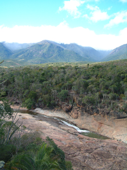
Protected areas of the world -
-

Flamingos at the Ras Al Khor Wildlife Sanctuary
This is a list of protected areas of United Arab Emirates:- Abu Dhabi Mangrove and Coastal Wetland Reserve
- Ain al Faydah National Park
- Al Awir Nature Reserve
- Al Khawanij Nature Reserve
- Al Maha Nature Reserve
- Al Marmoom Desert Conservation Reserve
- Al Wohoosh Desert Conservation Reserve
- Dubai Desert Conservation Reserve National Park
- Hatta Nature Reserve
- Jabal Ali Wildlife Sanctuary
- Khor Kalba Nature Reserve
- Marawah Marine Protected Area
- Mushrif National Park
- Nadd Al Sheba Nature Reserve
- Rams Lagoon Reserve
- Ras Al Khor Wildlife Sanctuary
- Wadi Wurayah National Park
- Zirkuh Island Bird Sanctuary
-
There are four categories of protected areas in India, constituted under the Wildlife Protection Act, 1972. Tiger reserves consist of areas under national parks and wildlife sanctuaries. There are 53 tiger reserves in India. the protected areas of India cover 173,629.52 square kilometres (67,038.73 sq mi), roughly 5.28% of the total geographical area of the country. (Full article...)
-

A family of Asiatic lions at Gir National Park
The Gujarat state of western India has four National Parks and twenty-three wildlife sanctuaries which are managed by the Forest Department of the Government of Gujarat. (Full article...) -
Cadw is the historic environment service of the Welsh Government which manages historical buildings and ancient monuments in Wales. (Full article...)
-

Cranes at Sevan National Park
This is a list of protected areas in Armenia that are categorized as follows: 4 national parks, 3 state reserves, 27 state sanctuaries and 5 botanical gardens. (Full article...) -
The state of Johor in Malaysia is noted for its national parks and forest reserves which preserve virgin rainforests known for its biodiversity and endangered species of animals.
Mangrove swamps and coral reefs are also protected within these parks. (Full article...) -
This list of protected areas of Quebec includes federally, provincially and municipally administered parks and wildlife reserves in Quebec, the largest province in Canada. (Full article...) -
-
Andohahela National Park in southern Madagascar
The national parks of Madagascar include all officially recognized protected areas as of 2015. The protected areas network of Madagascar is managed by the Madagascar National Parks Association (PNM-ANGAP). The network includes three types of protected areas: Strict Nature Reserves (IUCN category Ia), National Parks (IUCN category II) and Wildlife Reserves (IUCN category IV). At the 2003 IUCN World Parks Congress in Durban, the Malagasy President, Marc Ravalomanana, announced an initiative to more than triple the area under protection from approximately 17,000 km2 (6,600 sq mi) to over 60,000 km2 (23,000 sq mi) (from 3% to 10% of Madagascar's area). This "Durban Vision", as it has been dubbed, involved broadening the definition of protected areas in the country and legislation has been passed to allow the creation of four new categories of protected area: Natural Parks (IUCN category II), Natural Monuments (IUCN category III), Protected Landscapes (IUCN category V), and Natural Resource Reserves (IUCN category VI). As well as allowing these new objectives for protected areas management, the new legislation also provided for entities other than PNM-ANGAP to manage protected areas, such as government ministries, community associations, NGOs and other civil society organizations, and the private sector. (Full article...) -
Bihar is a state in East India. It is bounded by Uttar Pradesh to the west, Nepal to the north, West Bengal to the east and Jharkhand to the south. About 7% of the state is protected forest area. (Full article...)
-
This is a list of protected areas in Bulgaria which includes 3 national parks, 11 nature parks and 55 nature reserves. The national policy for governing and management of the protected areas is implemented by the Ministry of Environment and Water. The first nature park in Bulgaria and the Balkan Peninsula is Vitosha Nature Park, established in 1934. All of the nationally protected areas in Bulgaria are also part of the Natura 2000 network of protected natural areas in the territory of the European Union. Bulgaria has some of the largest Natura 2000 areas in the European Union covering 33.8% of its territory.
- Parks and reserves in italic letters are part of Global 200 ecoregions.
-
-
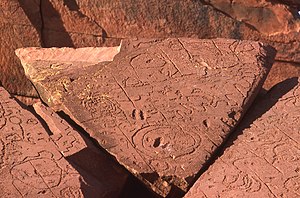
Rock carvings at the Ewaninga Rock Carvings Conservation Reserve
The protected areas of the Northern Territory consists of protected areas managed by the governments of the Northern Territory and Australia and private organisations with a reported total area of 335,527 square kilometres (129,548 sq mi) being 24.8% of the total area of the Northern Territory of Australia. (Full article...) -

Vegetation outside Goz Beïda
The wildlife of Chad is composed of its flora and fauna. Bush elephants, West African lions, buffalo, hippopotamuses, Kordofan giraffes, antelopes, African leopards, cheetahs, hyenas, and many species of snakes are found there, although most large carnivore populations have been drastically reduced since the early 20th century. Elephant poaching, particularly in the south of the country in areas such as Zakouma National Park, is a severe problem. (Full article...) -
Protected areas of Estonia are regulated by the Nature Conservation Act (Estonian: Looduskaitseseadus), which was passed by the Estonian parliament on April 21, 2004 and entered into force May 10, 2004.
Overall Estonia has 15403 protected areas covering 21% of the country land and 18% of it marine and coastal territory, including 6 national parks: Lahemaa National Park, Karula National Park, Soomaa National Park,Vilsandi National Park, Matsalu National Park, and Alutaguse National Park (Full article...)


Selected world maps
-
 Only a few of the largest large igneous provinces appear (coloured dark purple) on this geological map, which depicts crustal geologic provinces as seen in seismic refraction data
 -
 The world map by Gerardus Mercator (1569), the first map in the well-known Mercator projection
 -
 Time zones of the world
 -
 United Nations Human Development Index map by country (2016)
 -
 The Goode homolosine projection is a pseudocylindrical, equal-area, composite map projection used for world maps.
 -
 Index map from the International Map of the World (1:1,000,000 scale)
 -
 1516 map of the world by Martin Waldseemüller
 -
 A plate tectonics map with volcano locations indicated with red circles
 -
 Mollweide projection of the world


World records
- List of Olympic records in athletics
- List of world records in athletics
- List of junior world records in athletics
- List of world records in masters athletics
- List of world youth bests in athletics
- List of IPC world records in athletics
- List of world records in canoeing
- List of world records in chess
- List of cycling records
- List of world records in track cycling
- List of world records in finswimming
- List of world records in juggling
- List of world records in rowing
- List of world records in speed skating
- List of world records in swimming
- List of IPC world records in swimming
- List of world records in Olympic weightlifting
Topics

Continents of Earth | ||||||||
|---|---|---|---|---|---|---|---|---|
| ||||||||
| ||||||||
| ||||||||


| Cenozoic Era (present–66.0 Ma) |
| ||||||||||||
|---|---|---|---|---|---|---|---|---|---|---|---|---|---|
| Mesozoic Era (66.0–252 Ma) |
| ||||||||||||
| Paleozoic Era (252–539 Ma) |
| ||||||||||||
| Proterozoic Eon (539 Ma–2.5 Ga) |
| ||||||||||||
| Archean Eon (2.5–4 Ga) | |||||||||||||
| Hadean Eon (4–4.6 Ga) | |||||||||||||
ka = kiloannum (thousands years ago); Ma = megaannum (millions years ago); Ga = gigaannum (billions years ago). See also: Geologic time scale • | |||||||||||||
| Locations | ||
|---|---|---|
| Related | ||

| |||||||||||||||||||
| |||||||||||||||||||
| |||||||||||||||||||

Economic classification of countries | |||||
|---|---|---|---|---|---|
| Three-World Model | |||||
| Gross domestic product (GDP) |
| ||||
| Gross national income (GNI) | |||||
| Wages | |||||
| Wealth | |||||
| Other national accounts | |||||
| Human development | |||||
| Digital divide | |||||
| Net international investment position (NIIP) | |||||
| Technological |
| ||||
|---|---|---|---|---|---|
| Sociological | |||||
| Ecological |
| ||||
| Biological |
| ||||
| Astronomical | |||||
| Eschatological |
| ||||
| Others |
| ||||
| Fictional | |||||
| Organizations | |||||
Categories

Wikimedia
The following Wikimedia Foundation sister projects provide more on this subject:
-
 Commons
Free media repository -
 Wikibooks
Free textbooks and manuals -
 Wikidata
Free knowledge base -
 Wikinews
Free-content news -
 Wikiquote
Collection of quotations -
 Wikisource
Free-content library -
 Wikispecies
Directory of species -
 Wikiversity
Free learning tools -
 Wikivoyage
Free travel guide -
 Wiktionary
Dictionary and thesaurus


